LiDAR-powered Digital Twins are ready to deliver on the promise of ‘Intelligent Railways’
Developing a “Digital Twin” of infrastructure and assets is widely accepted as key to underpinning digital innovation, and many versions involve LiDAR. But Digital Twins vary hugely in the details – and the details are crucial. The top two details for railways are 1. accurate location and 2. effective integration for end-users. Accurate location across multiple capture sources (from different technologies and suppliers) provides the first stage in effective integration, creating a Multi-Modal Digital Survey that is the single source of holistic truth for end-users. Rail organisations looking to seize the promise of Digital Twins can accelerate innovation delivery with source-agnostic, accurate date/time/location stamped data capture accessible to end-users. Read on for the opportunities that this can drive.
Better Asset Management through Digital Twins
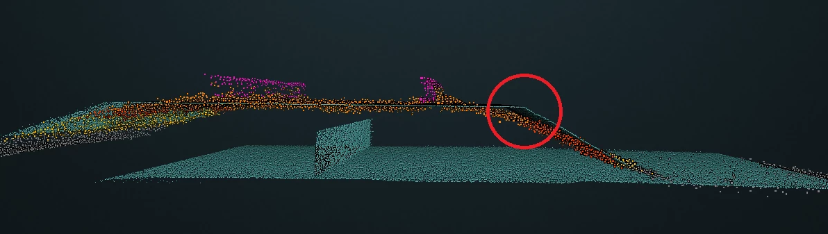
Implementing Digital Twins and AI can significantly improve railway asset management. Digital Twins visually represent physical railway infrastructure, from structures and ballast to signals and equipment cases. Quantified asset position and integrity standards compliance can be efficiently delivered using high-accuracy automated inspection data capture to reduce reliance on manual processes.
Techniques like Machine Learning can process inspection data to automatically detect asset changes before they become critical. Digital Twins and AI provide a better understanding of asset condition risks, improving reliability. The result is enhanced inspection economics through more frequent and proactive monitoring at lower costs. Beyond compliance, Digital Twins enable railways to identify and simulate change, analysing assets to gain insights for preventative maintenance.
Optimised Maintenance with AI-Driven Intelligence
Railways can also realise significant benefits by leveraging AI-powered platforms for maintenance. These systems, hosted in the cloud, integrate inspection data, subject matter expertise, and third-party data feeds. Advanced analytics and machine learning algorithms process this data to identify maintenance needs and predict problems.
Issues can be detected early, reducing the likelihood of disruptive failures. Maintenance activities can also be optimised and scheduled proactively. Railways gain trusted data security, intuitive interfaces, reduced manual effort with AI-driven platforms – and maintenance transitions from reactive to prescriptive. Railways improve economics through increased uptime and lower costs while ensuring the highest safety standards.
Overcoming challenges in optimising LiDAR Digital Twins for Railways
To maximise the benefit of LiDAR Digital Twins, key challenges must be overcome based on understanding the specific characteristics of the railway environment and addressing real railway end-user needs. Five key challenges (and their resolutions) on the journey from data capture to railway end-user are set out below:
Challenge 1: support for LiDAR sensors during capture – resolved with automation
Automation with unattended hardware systems transforms data capture, reducing safety risks for manual track inspection and obviating painstaking hardware device management and operational support. End-to-end automation radically reduces the cost per mile of data acquisition and feeds an AI-driven pipeline for quicker turnaround to produce post-processed outputs. Reduced costs and quicker turnaround times make frequent capture affordable, offering a richer dataset for greater insight.
Challenge 2: locating LiDAR data relative to legacy systems and new data – resolved with accurate positioning
To maximise usefulness, captured data must accurately align (not only with itself, precisely and repeatably) but also with the railway network’s own Linear Reference System. A single source of location truth applied across all sensing data and federated across technologies and capture vehicles enables a holistic Digital Twin. This beneficial Digital Twin aligns LiDAR data, processed outputs and other sensor streams used in the maintenance and asset planning decision process, such as rail profile, track geometry and video.
Challenge 3: prompt and cost-effective big-data transfer – resolved with intelligent data management
Even with automated capture and accurate locations, the potential volume of data generated is enormous – typically 100GB+ per sensor per day from a vehicle in normal passenger service. Data management starts with recognising that not all data is required all the time. The next hurdle is to enable appropriate data prioritisation, offloading and telematics. The optimum mechanism for this will depend on the network type, environmental conditions and distance covered. This will then inform a railroad’s best networking infrastructure and objectives.
It is foreseeable that in high-value, high-traffic networks, permanent 5G wayside P-MEC (private multi-access edge compute) networks can deliver the real-time offloading of all sensor data from a host of data capture devices across the network. On the other hand, the value of the network and its geographic footprint need to be considered. For example, it could be hard to justify the economics of a nationwide private 5G rollout across a 40,000-mile freight network. However, covering key corridors within this network might be beneficial.
Challenge 4: gaining relevant insights – resolved with AI data processing informed by engineering prioritisation
So, you have automated the data capture and received the data quickly and economically. Now it’s time to get something useful from this content-rich, high-fidelity data! A deep understanding of the data and end solution requirements (value use cases) mapped to the engineering requirements of the network is now crucial. For example, it’s most likely only necessary to map vegetation growth at the start and once at the end of the growing season, with potentially more frequent checks in identified risk areas. But for OLE height and stagger, it is helpful to measure this every three months, with local updates before and after significant trackworks.
Understanding what data is required, when and at what frequency is critical to delivering automated service using LiDAR data at scale.
Challenge 5: enabling more integrated future insights – resolved with AI/ML-based deep analytics and automated reporting
A few organisations can deliver railway discipline-specific machine-learning to turn the captured data into business value, delivering measurable cost savings, safety improvements and improved network performance.
Taking the automatically captured and offloaded LiDAR data and building accurate human-level AI/ML-powered data analysis models is where real engineering problems are solved. Railway system domain knowledge enabled fundamental asset expertise and applied intelligence to be gained from subject matter experts, helping the machines learn and tune, feeding back to continually improve the assessment performance and reliability.
Such automated pipelines must constantly be improving and learning, and only then will a machine-augmented inspection process become a reality.
LiDAR, a silver bullet?
In itself, LiDAR is not a silver bullet, but the technology plays a vital role in developing intelligent railways that can operate more efficiently, safely and with fewer disruptions.
To enable and accelerate intelligent railways through the use of Digital Twins and advanced automated analytics, LiDAR at scale is now a reality. LiDAR data can be used to produce precise 3D models of railway assets. These models can then be used to detect, diagnose and predict problems before they occur and optimise maintenance processes.
To date, LiDAR’s biggest challenge has been the time-consuming and costly process of attended hardware data capture, manual data transfer, and manipulation of data processing to get accurate point clouds. Traditionally, it has taken experienced analysts and surveyors excessive time to translate the point cloud information into usable outputs that generate measurable gains. This has meant deployment on a precise, smaller-scale project basis.
With progress in emerging technologies like AI, cloud and IoT, it is possible and even demonstrable that railways can deliver real solutions to engineering problems using LiDAR scans of the network that will solve existing problems and fundamentally improve the economics of running modern railways.
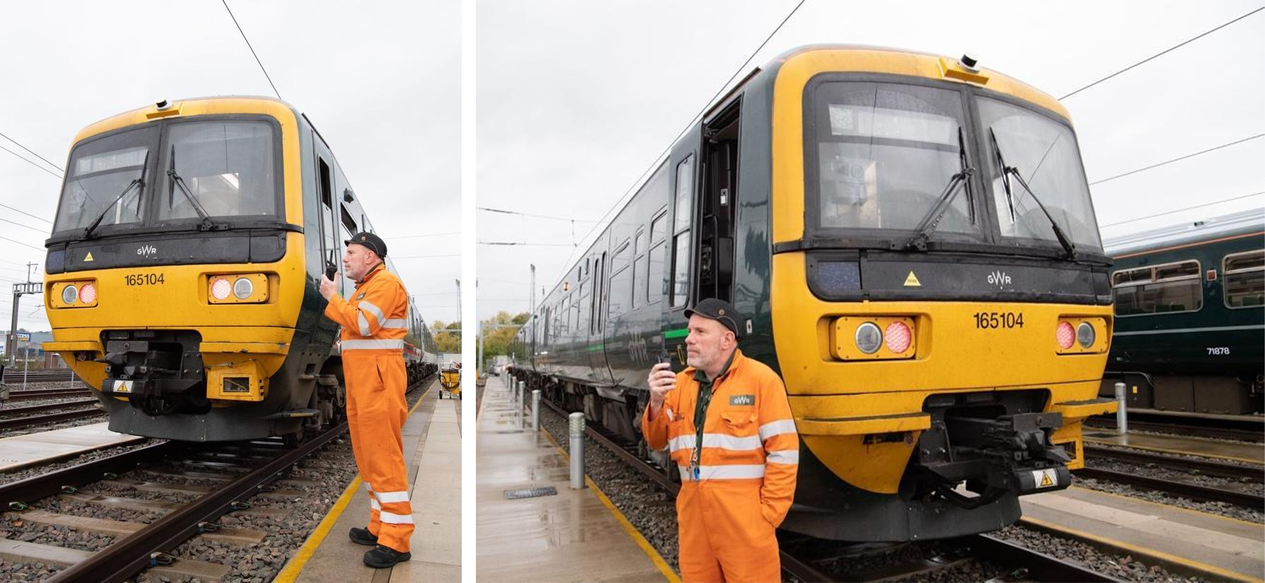
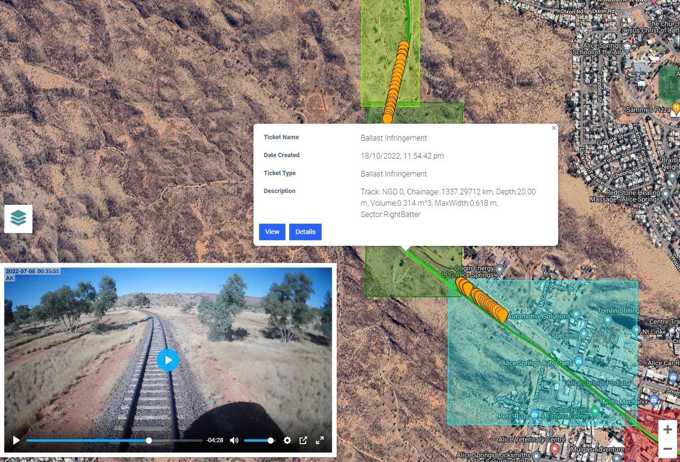
Cordel has successfully implemented LiDAR technology in the UK by installing it on in-service Class 165 trains in partnership with Network Rail, Great Western Trains, and Angel Trains. Similarly, ARTC in Australia has utilised Cordel’s Wave 32 LiDAR on the AK car measurement train to cover over 12,500 km of freight network across Australia annually for the past four years.
How Cordel helps address these challenges and exploit the benefits of LiDAR capture
Cordel has developed a significantly more efficient way to capture your network Digital Twin and deliver valuable processed data and associated use cases across your business stakeholders. This starts from the high-fidelity capture where our sensor hardware, including LiDAR, HD Camera and Location Services, are provided as a minimal hardware footprint through to the holy grail – a fully automated processing pipeline with applied AI/ML to ensure rapid delivery of the processed data to drive immediate business value.
Ready to Get Started?
If you’re ready to implement AI and Digital Twins in your railway, the first step is to schedule a consultation with our team of experts. We’ll analyse your operations, identify high-potential use cases, and provide a roadmap for successful implementation. Contact us today to get started!
Transform your infrastructure inspections
Visit our contact page to get started today or book a demo to give us the opportunity to show you first hand how we enable deeper insights into critical infrastructure.